
Why you need an estate map
Think estate maps are a quaint throwback? Think again-they're actually an important part of successful ownership, says Emma Hughes
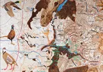
During the last Elizabethan age, having a map made of your estate was at the top of every landowner's to-do list. The dissolution of the monasteries had created a huge number of new demesnes, and their owners were anxious to make things official. The images they commissioned served a decorative purpose as well as a practical one, with some depicting grazing sheep and labourers cutting hay in the fields. By the mid 19th century, their popularity had waned, thanks to the introduction of more reliable Ordnance Survey maps. However, they're experiencing a renaissance as landowners realise that, far from being a whimsical anachronism, personalized maps play a vital role in effective estate management.
‘They're such a useful tool,' believes Philip Eddell of Savills' country-house consultancy (01635 277709). ‘At a basic level, they give you an understanding of what you own. But mapping an estate is also essential to the calculation of farm subsidies, for example -and it's very hard to look around a wood on the ground and work out what's going on.' The data the process puts within your reach could also prove vital to resolving tricky boundaryrelated issues, from planning disputes to incidents of fly-tipping. So how should you go about getting your estate mapped?
* Subscribe to Country Life and save

According to Michael McCullough, who heads Knight Frank's digitalmapping department, ‘there is no set procedure'. However, it usually begins with a look at the estate's title in an attempt to spot any gaps. Next, a GIS search (using a Geographical Information System-the technology behind Google Maps), Ordnance Survey data and site visits are used to establish the boundaries. Finally, this information is all pulled together into one document to create what Mr McCullough refers to as ‘your basic estate map This can then be tailored to the owner's interests by overlaying it with specific environmental data-‘the sort of thing that doesn't make much sense until you import it into your own mapping system'. The end result is relevant to owners whose estate has been in their family for generations and first-time buyers alike. Indeed, the latter can use it as a way of making their mark-if there's the name of a wood you'd like to change, for example, the agents mapping it can feed your request back to the Ordnance Survey.
Two years ago, Mr McCullough was asked to map the land and rights of the 25,500-acre Trawsgoed estate in Ceredigion, mid Wales (www.trawsgoed-estate. co.uk), which stretches from the Ystwyth Valley into the Cambrian Mountains. Once the second largestestate in Wales, it's now a mix of residential and agricultural holdings, community property and areas with mineral, sporting and manorial rights over them. A significant proportion of it is also registered common land, and there are several SSSIs.‘It's a complex historic estate-our landholdings are a bit like a jigsaw puzzle,' explains director of Trawsgoed Estates Limited John Vaughan, who took over after leaving Savills. ‘Mapping gives us a helpful overview.' The decision to call in Knight Frank was triggered by an impending sale.
‘We'd identified some 800 acres we wanted to sell. Some of the boundaries were already clearly defined, but there were a few we wanted to make more exact.'Although Mr Vaughan is overseeing a sizeable area, he feelsthat mapping is a valuable step mfor any landowner to take. ‘It's very important to have a clearidea of what you own, whether that's 20 acres or 20,000 acres, and what your responsibilities are-things such as the upkeep of hedges and ditches.' He also believes that mapping your land gives you a sense of continuity.‘There are maps of the estate that date back to 1776,' he reveals. ‘They're beautifully done.'

One craftsman still working in this tradition is furniture maker Sam Anderson (01969 622072; www.samandersonfinefurniture.co.uk), who's based on the edge of the Yorkshire Dales National Park. Recently, he was commissioned by the owner of a local shooting estate to create a one-of-a-kind image of his land. Taking an Ordnance Survey map as his starting point, he fashioned a version of it in wood veneer. Working with his client, he then marked out the drives, the directions from which the birds come, the types of birds guns can expect to find on each drive and the positions of the pegs. The map took several months to complete, and Mr Anderson hopes it will be treasured by future generations. ‘It's a tactile, beautiful piece that reflects how the estate looked at the time it was made,' he says.
Mapping your estate is a significant investment. Knight Frank estimates the cost at between £1 and £3 per acre, and Mr Anderson charges £2,500 a week for his services. Nevertheless, he believes that more and more owners are waking up to the value of having their estates mapped: ‘I got into this line of work after being approached by a client. The current climate is slightly prohibitive, but the interest is definitely there.
* Follow Country Life property on Twitter
